The problem
The ocean absorbs about a third of the carbon dioxide humans emit each year, and the Southern Ocean around Antarctica accounts for about 40% of the global ocean’s uptake, according to CSIRO. CSIR in South Africa adds that it also takes up about 75% of the heat generated by excess carbon dioxide that the oceans absorb.
But this is also one of the least measured parts of the climate system. The Southern Ocean has hurricane-force winds, waves of more than eight metres, drifting icebergs and freezing temperatures. Research ships are expensive, cover only a narrow patch of ocean and often stop work in the southern winter. Without winter data, estimates of how much carbon the ocean absorbs remain uncertain, and so do climate projections.
The product
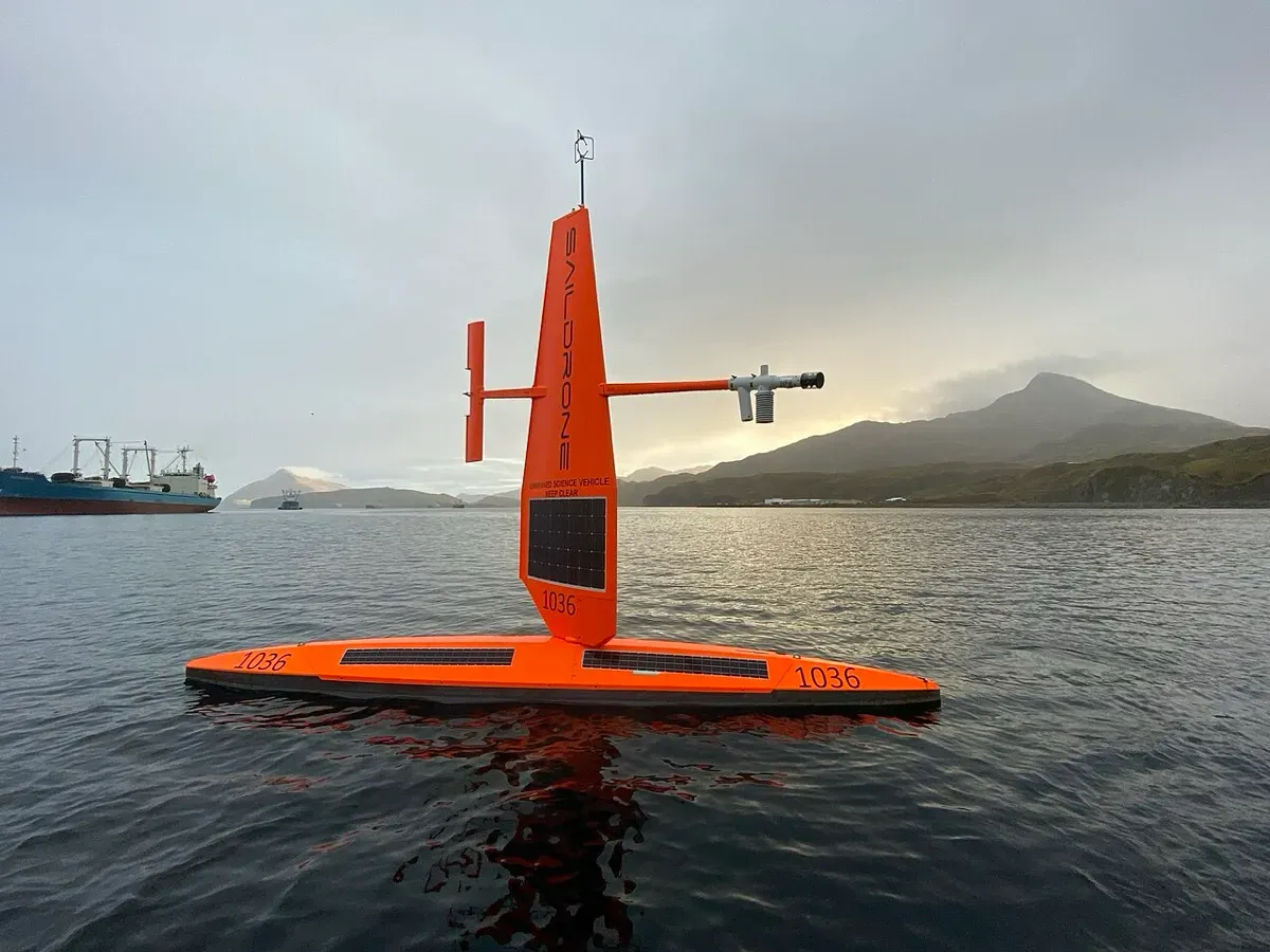
The Saildrone Explorer is a seven-metre uncrewed surface vehicle that looks, as The Guardian put it, like a large hi-vis orange kayak. A heavy keel keeps it upright, a rudder steers it and a fixed solid sail drives it with the wind. Its sensors run on solar power, so it needs no fuel and can stay at sea for months.
For the COCO2 mission, SD-1092 measures carbon dioxide in the water and air, wind speed, atmospheric pressure, solar radiation, sea temperature, salinity and chlorophyll. Saildrone monitors it remotely by satellite, and scientists can see data in near real time through a mission portal.
Saildrone also builds larger vehicles: the 10 m Voyager, the 20 m Surveyor and the 52 m Spectre. The company says it has more than 12 years of operations and 60,000 days at sea behind it.
How it works
- Deploy. A small boat tows the Explorer out of harbour near Hobart.
- Sail. Wind drives it east around Antarctica, past New Zealand and South America.
- Measure. Solar-powered sensors log carbon dioxide and weather continuously.
- Steer. Scientists adjust the route to target the most uncertain regions.
- Transmit. Data travels by satellite to a near real-time portal.
- Return. After about 200 days it returns to Hobart for new sensors.
Timeline
| Date | Milestone |
|---|---|
| 2019 | A Saildrone Explorer circumnavigates Antarctica in 196 days, covering 11,879 nautical miles |
| Apr 2025 | Saildrone sets up a European subsidiary, backed by a $60 million round led by Denmark’s EIFO |
| 17 Aug 2026 | Saildrone opens its EU headquarters in Copenhagen |
| 20 Sep 2026 | SD-1092 deploys from Hobart for COCO2 |
| Late 2026 | Second COCO2 Explorer due, about three months after the first |
| About Apr 2027 | SD-1092 expected back in Hobart after about 200 days |
| 2031 (planned) | Five-year COCO2 programme due to end |
Impact and numbers
Saildrone has done this before. In 2019 an Explorer circumnavigated Antarctica, sailing 11,879 nautical miles in 196 days. COCO2 turns that one-off feat into a routine. A new Explorer will launch about every three months, until four are spread around the Southern Ocean, with each returning to Hobart for new sensors and then setting off again.
The vehicle has already been tested hard. CSIRO’s Elizabeth Shadwick told The Guardian that the day after deployment it faced eight-metre waves and 35-knot winds; Saildrone reported winds of up to 50 knots. “It’s quite a robust little device,” Shadwick said.
COCO2 is led by NOAA’s Pacific Marine Environmental Laboratory and Columbia University, with the University of Washington, CSIRO, the Australian Antarctic Program Partnership and South Africa’s CSIR. It is funded by Schmidt Sciences. Columbia’s Lamont-Doherty Earth Observatory will use machine learning to find the highest-uncertainty regions and redirect the vehicles. CSIR’s Sandy Thomalla, a lead author on the IPCC’s Seventh Assessment Report, says the goal is to reduce uncertainty in global carbon budget estimates and close a critical winter data gap. CSIRO’s Shadwick calls it the first multi-year campaign to deploy USVs in the Southern Ocean specifically to collect data in seasons and regions where ship traffic is limited. Crewed research vessels sailing between Hobart and Antarctica cover only a narrow strip of ocean; the Explorers will cover far more distance and time.
Honest caveats
Defence focus. Saildrone’s own website now leads with defence and intelligence missions. Its European expansion centres on navy customers: four Voyagers completed a six-month deployment for Denmark’s defence procurement agency, and Janes reports plans to build 10 to 15 Voyagers a year for surveillance and seabed mapping. This story covers only the civil science mission.
Inconsistent figures. CSIRO and The Guardian give about 22,000 km per voyage; Saildrone’s release quotes “over 24,000 nautical kilometres”. Timeline dates after September 2026 are plans.
Data, not cuts. Measuring the ocean carbon sink does not reduce emissions. It improves the numbers that climate targets rely on.
Robots can fail. The Southern Ocean is extremely harsh, and a vessel lost far from land may not be recovered.
What’s next
The second COCO2 Explorer is due about three months after the first, and the fleet will be adjusted over five years to focus on regions with the largest data gaps. Once vessels return, data will undergo quality checks before release to researchers. Columbia’s Galen McKinley says the team will also apply model and AI based observing strategies, so that each voyage collects the measurements that most improve estimates of the carbon sink. If the approach works, it could become a template for monitoring other remote seas where ships rarely go.
Why it matters for Europe and green buyers
For Europe, better Southern Ocean data sharpens the global carbon budget that underpins EU climate targets and carbon budgets. Saildrone also now has European roots, with a Copenhagen headquarters and vehicle production planned in the Netherlands, Norway and Poland, although those vehicles are mostly for defence.
For India, whose monsoon and coastline depend on how the oceans store heat and carbon, better Southern Ocean data improves the models Indian scientists use. For the world, cheap and persistent robotic observers can finally measure the places ships cannot reach.
Sources & image credits
- Saildrone, “Saildrone Embarks on a Multiyear Expedition to Monitor Carbon Exchange in the Southern Ocean”, Sep 2026. https://www.saildrone.com/news/saildrone-embarks-multiyear-expedition-monitor-carbon-exchange-southern-ocean
- CSIRO, “Ocean drones set to brave the Southern Ocean for science”, Sep 2026. https://www.csiro.au/en/news/All/News/2026/September/Ocean-drones-set-to-brave-the-Southern-Ocean-for-science
- CSIR, “Saildrone ahoy: Ocean scientists prepare to crunch data for Global Carbon Budget”, Sep 2026. https://www.csir.co.za/media-hub/media-room/saildrone-ahoy-ocean-scientists-prepare-to-crunch-data-for-global-carbon
- The Guardian, “‘Robust little’ vessel begins treacherous 22,000km journey around Antarctica in the name of climate science”, 26 Sep 2026. https://www.theguardian.com/environment/2026/sep/26/saildrone-unmanned-hurricane-proof-ship-antarctica-climate-hobart
- Saildrone, “Saildrone Announces Major European Expansion with Local Production, Operations, and Business Development”, 18 Aug 2026. https://www.saildrone.com/media-room/press-releases/saildrone-announces-major-european-expansion-local-production-operations-business-development
- Janes, “DDAC 2026: Saildrone planning to build 10 to 15 Voyager USVs per year”, 2026. https://www.janes.com/defence-intelligence-insights/defence-news/defence/ddac-2026-saildrone-planning-to-build-1015-voyager-usvs-per-year
- Wikimedia Commons, “Saildrone in 2019 NOAA Arctic mission”. https://commons.wikimedia.org/wiki/File:Saildrone_in_2019_NOAA_Arctic_mission.jpg
Images: “Saildrone in 2019 NOAA Arctic mission”, NOAA and Saildrone, 2019, public domain, via Wikimedia Commons. Shows the same vehicle class, not SD-1092.